Hunga Tonga Hunga Ha'apai One Year On
On 15 January 2022 the active volcano Hunga Tonga Hunga Ha’apai erupted, sending a shockwave around the world and triggering tsunami warnings around the Pacific.
AUT’s School of Science Marine Geologist Dr Marta Ribó Gené is part of a multi-institution, multi-disciplinary team lead by the University of Auckland’s Professor Shane Cronin, surveying the seafloor around Hunga submarine volcano, and what they’ve learnt will help with future disaster preparedness.
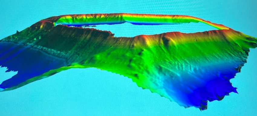
“We used a multibeam echo sounder which emits a fan of acoustic soundings, giving us high resolution, detailed data about the seafloor,” says Dr Ribó .
In October 2022 the team travelled to Tonga, where they re-mapped the Hunga volcano following initial mapping in May 2022, and confirmed the volcanic activity visible as underwater gas plumes has dropped off, and the landslides visible on the southern crater rim seem to have stabilised.
They also mapped the seafloor morphology and structure of two other volcanoes in the Ha'apai group in Tonga, including the almost perfectly conical Tofua volcanic island, with the rim of the caldera sitting approximately500m above water, considered quiescent but with increasing volcanic activity; and the Fonuafo’ou volcano, which is entirely submarine 20km north of Hunga-Tonga.

The mapping of Fonuafo’ou is most exciting, as it is very similar in shape to Hunga volcano, with an approximately 5 km caldera, and could offer greater understanding of the impact submarine volcanoes have and the way they can potentially trigger tsunami.
“Fonuafo’ou was mapped for the first time, and the data we gathered will not only provide more accurate nautical charts, but also allow us to study a volcano very similar to Hunga,” says Dr Ribó. “The Pacific Tsunami warning system currently operates on the understanding that most tsunami are caused by earthquakes. The Hunga eruption caused a tsunami, and many areas of Tonga are still tsunami dead zones. The new acquired data from Tofua and Fonuafo’ou will help us deliver new knowledge crucial to understand and forecast volcanic tsunamic source mechanisms and predict the way tsunami waves shoal, helping communities to be better prepared.
“Being able to remap the seafloor over time builds our understanding of the evolution of submarine geological features such as submarine volcanoes. Having a precise knowledge of the continuous seabed changes worldwide is also important for navigational safety and should be considered for any assessment of modern and future offshore infrastructure (e.g., submarine cables, tidal turbines, wind power systems).”